Boundary Stone or Parish Marker? Reading the Clue
Learn how to read a boundary stone or parish marker, distinguish its purpose and use nearby records to check what its position can—and cannot—tell you.
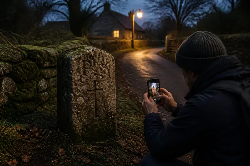
You find a weathered stone beside a lane, its face marked with a letter and a cross. Is it a boundary stone or a parish marker? The distinction matters: one describes a likely function, while the other suggests an association that may or may not be about a boundary.
What can you identify from the stone itself?
Look at each visible face from a safe position. Note the letters, symbols, material, shape and condition, and photograph the marks without touching or cleaning the stone. Moss, erosion and shadows can make an inscription hard to read; record uncertainty rather than turning a faint mark into a confident letter.
Initials might refer to a parish, estate, landowner, borough or other authority. A cross may also have more than one meaning. The inscription is a clue, not a label that settles the stone’s purpose.
How does its position help?
Record where the stone stands and what is nearby: a road junction, stream, wall, gate or bend in a lane. A phone mapping app can help save a location, while written directions from a public route make it easier for someone else to find the spot.
Other stones nearby may suggest a sequence, but they do not automatically mark a continuous legal line. Markers can be missing, moved or reused, and a hedge or ditch may have changed since the stone was set. Treat the surroundings as context, not proof.
How are a boundary stone and a parish marker different?
“Boundary stone” describes an apparent role: marking a boundary, a point on it or a division between areas. “Parish marker” describes a possible connection to a parish, but does not say whether the stone marks the parish edge, a route, a local limit or another parish-related feature.
The descriptions can overlap. A stone linked to a parish may stand on a boundary; another boundary stone may refer to adjoining owners or jurisdictions instead. The important question is what the stone was intended to indicate, not simply what initials it carries.
Say you find a stone with two initials beside an old lane, and no other markers are visible. You photograph the faces, note the lane’s nearby bend and save the location from a public path. If a parish description later names that bend as a boundary point, the evidence supports a possible parish-boundary connection; if the initials match an estate record instead, an estate-related interpretation becomes more plausible. Neither result, by itself, proves that the stone is original or fixes a present-day legal line.
Which records can help explain its purpose?
A county record office or local studies library may hold parish descriptions, minutes, surveys, estate papers or accounts of boundary perambulations. A perambulation records or recalls a circuit around a parish or other area, sometimes naming landmarks that can be compared with the stone’s setting.
Historic maps can show how roads, streams, field divisions and settlement edges were represented at different times. Check each map’s date, purpose, scale and legend. A map made for one administrative task may show a boundary differently from one made for another, or omit it altogether.
Search archive catalogues using the parish and nearby place names, then ask an archivist which records suit your question. If a description relies on a landmark that has disappeared, note the gap rather than forcing a match. A record may show that a boundary was recognised without establishing that a surviving stone is its original marker.
What should you do when the clues disagree?
Keep the original observation intact and add the revised reading beside it. For example, write “mark looks like P” in the first note, then add “possibly an estate initial” if a relevant document points that way. This preserves what was actually seen while making the later interpretation clear.
When sources differ, compare their dates and purposes before deciding what they describe. A parish may have been altered, while a marker belongs to an earlier arrangement. Keep each source tied to its period rather than drawing one timeless line from them all.
What questions help settle the identification?
Can a parish marker show the whole parish boundary?
Not necessarily. It may indicate one point, a section, an entrance or another parish-associated feature. Compare its position with a boundary description or map before treating it as evidence of the full perimeter.
Do initials prove who placed the stone?
No. Initials might name an authority, an adjoining area or an owner, and the lettering may be difficult to read. Record the marks as visible and look for a matching explanation in local records.
Does a stone on a mapped line settle the boundary?
It supports a possible connection, but the map and stone may belong to different dates or purposes. Check the map’s context and look for records describing the boundary or marker.
What if the inscription is unreadable?
Describe the visible features without guessing, and photograph the stone from different angles without altering it. A local archive or heritage group may hold an inventory or description that offers useful context.
How can you describe the result accurately?
- If the inscription is clear and a record explains it, then describe the stated connection and name the source; if not, record the marks as seen and avoid assigning an identity.
- If the stone aligns with a boundary description, then call it a possible boundary marker for that described line; if the location is uncertain, describe its setting without claiming alignment.
- If several markers share distinctive marks and positions, then note that they may form a related group; if they do not, treat each stone as a separate clue.
- If a map’s date and purpose fit the question, then use it as period-specific context; if they do not, seek a more relevant map or describe the mismatch.
- If the object lies on private land or in a protected place, then follow access rules and seek the appropriate local guidance; if access is unclear, do not enter or disturb the site.
- If an exact legal boundary matters for property, access or proposed work, then consult a qualified surveyor or solicitor; if it is a heritage question, ask an archivist or local heritage group for source guidance.
Distinguish the physical stone from the boundary it may indicate. A marker can survive after an administrative line changes, while a boundary can remain in records after its marker disappears. For a boundary stone or parish marker, a precise description of what is visible—and what remains uncertain—gives the next reader a sound basis for checking the interpretation.